
Maps4AfricaSM mapping system operates on Windows 95/98/NT. Designed for ease of use and high speed display, the new system operates either in standalone mode or is controlled by an external application system. Maps4AfricaSM interfaces to ESS NT and ESS Pro, two variants of Sysman's Command and Control software. A published Application Interface Specification makes it easy and straightforward for other software to interface to, and drive the mapping system.
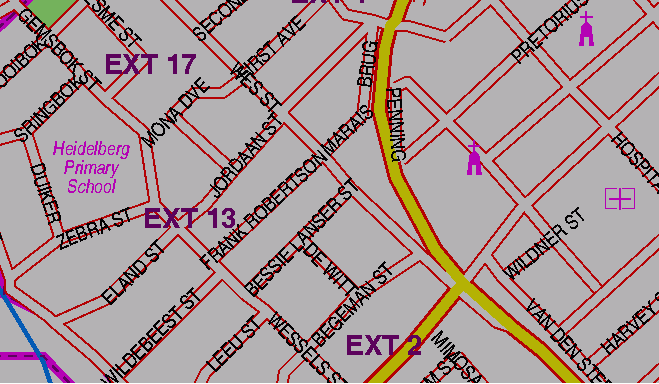
Figure 1. 1:20,000
In a command and control environment the mapping system operates on either dedicated PC mapping workstations or on an existing call taker / dispatching PC workstation. In the case of the latter, Software Makers recommend the use of an additional mapping monitor which can be supported on the same PC. Workstations should be configured with at least a 333 MHz Pentium II processor, 64 Mb of memory, 4.3 Gb HHD and a fast SVGA graphics card (on Windows 98, a graphics card is required for each monitor).
Mapping Software is tightly integrated into ESS NT and ESS Pro. Maps can be automatically displayed once an incident location has been entered. A variety of operator facilities are supplied for manipulating maps.
Speed of map display is typically less then one second. Maps can be scrolled and zoomed at similarly high speeds. One, two or four map windows can be displayed. Each map window can be separately controlled. Alternatively, a mapping window can be linked to another, for example, to enable information to be displayed at two scales.
Maps suitable for an emergency environment are supplied as part of the solution. Both Raster and Vector maps are provided together with essential data such street names etc. Integration of other maps supplied from other sources can be done on a time and materials basis. Vectors can be overlaid over raster images and map scale is automatically adjusted to display the full vector.
Geographic information facilities include the overlaying of current incident locations and historical information. The latter can be filtered. The display of real time, vehicle tracking information is supported.
Maps4AfricaSM was developed by Software Makers to counter the high costs of imported software. Maps are designed for readability in a control room environment. Costs of maps is dependent upon the geographic areas required. All cities and towns plus most smaller towns and an SA Road Atlas are available.
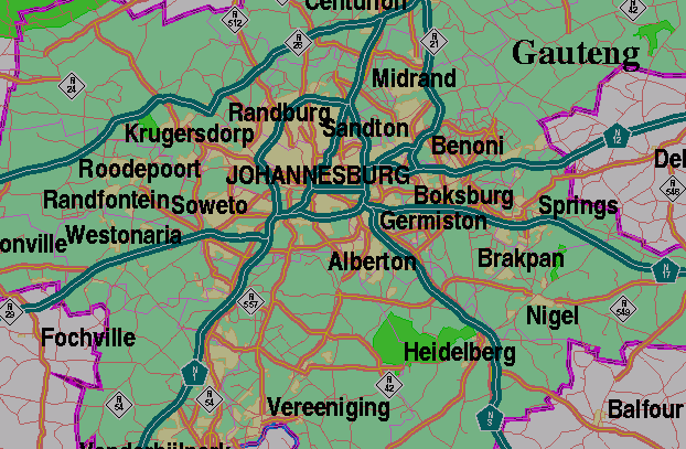
Figure 2. 1:2,400,000
EnvironmentWindows 95/98/NT. Recommended: 333 MHz Pentium II, 64 Mb memory, 4.3 Gb HDD, SVGA graphics card, 17" high quality monitor.
Databases Types SupportedAccess, dBase, FoxPro, Lotus 1-2-3, Excel, Paradox, Lotus Notes, Text. Database records are presented as icons with label below. Icon size: 8, 16, 24, 32, 40, 48, 56, 64 pixels Icons library: subject to customizing
Map ScalesStreet level 1:20,000 and 1:40,000
Suburbs level 1:60,000 and 1:120,000
Town key map 1:240,000 and 1:480,000
Province 1:2,400,000 and 1:4,800,000
Country 1:12,000,000 and 1:24,000,000
Map ControlsNumber of map windows: 1, 2 or 4 Linked maps: 2 and 1, 3 and 1, 3 and 2, 4 and 1, 4 and 2, 4 and 3. Co-ordinate display: ON or OFF Brightness: 5% to 100% Zoom In / Out: by 1, 2 or 3 levels Scroll in four directions as well as diagonally Variable speed of scrolling Different modes of zooming
Menu Driven GraphicsLocate map by lat long, street, suburb, town, crossroad. ADD or DELETE circles, lines, zones, text and icons. Define attributes and position by hand.
Vector OverlaysHighlight shape of a road vector, boundary of a suburb, or boundary of a town. Highlight area of a suburb, or area of a town.
External Software ControlMaps4AfricaSM may be controlled by other applications (bidirectional communication). See page 3 for a list of commands.
MiscellaneousWINDOW-OPEN, n
WINDOW-LINK, n2, n1
WINDOW-UNLINK, n2, n1
COORD-ON
COORD-OFF
MESSAGE, "message"
BIT_MAP, width, height, pathname
SLEEP, n
BRIGHTNESS, percent
DatabasesDB-OPEN, maps, DBtype, DBname, DBtable
ATTRIBUTE-ADD, Group\Name, n{, att, val}*n
ATTRIBUTE-DELETE, Group\Name
ICON-ADD, maps, Group\Name, lat, long, iNum, iSize, iCol, label, lSize, lCol, bCol
ICON-DELETE, maps, Group\Name, lat, long
ICON-DELETE-ALL, maps, Group\Name
CLEAR, maps
Locating the mapLOCATE, map, scale, lat, long
LOCATE-STREET, map, scale, street, suburb, town
LOCATE-SUBURB, map, scale, suburb, town
LOCATE-TOWN, map, scale, town
LOCATE-XROAD, map, scale, street1, street2
GraphicsZONE-ADD, maps, Group\Name, style, lThick, lCol, n{, lat, long}*n
ZONE-DELETE, maps, Group\Name, lat, long
ZONE-DELETE-ALL, maps, Group\Name
CIRCLE-ADD, maps, Group\Name, lat, long, radius, lThick, lCol
CIRCLE-DELETE, maps, Group\Name, lat, long
CIRCLE-DELETE-ALL, maps, Group\Name
TEXT-ADD, maps, Group\Name, lat, long, text, tSize, tCol
TEXT-DELETE, maps, Group\Name, lat, long
TEXT-DELETE-ALL, mm, Group\Name
LINE-ADD, maps, Group\Name, style, lThick, lCol, n{, lat, long}*n
LINE-DELETE, maps, Group\Name, lat, long
LINE-DELETE-ALL, maps, Group\Name
Vector overlaysSTREET-ON, maps, street, suburb, town, lThick, lCol
STREET-OFF, maps, street
SUBURB-ON, maps, suburb, town, lThick, lCol
SUBURB-OFF, maps, suburb
TOWN-ON, maps, town, lThick, lCol
TOWN-OFF, maps, town